Why focus on the Chesapeake Bay?
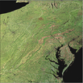
The Chesapeake Bay is a unique ecosystem encompassing coastal areas, wetlands, and heavily populated urban centers such as Baltimore and Washington, D.C. (see an image if the Bay). A significant amount of remotely sensed data is available for the region, yet this data may be located at different and unconnected sites. Increasing integrated access to data related to the Chesapeake Bay will support both education and research and enhance our our understanding of this important ecosystem.
Why is remotely sensed data important?
Remotely sensed data is an invaluable tool that can be used to enhance our understanding of the world around us. It provides us with the ability to analyze land use/land cover, explore and research the biodiversity and habitats of the region, and gain deeper insight into the challenges to the ecosystem and opportunities to address those challenges.
What other data can be found
ChesapeakeView is developing new data partnerships all the time. Data in the Bay region is created by a wide range of organizations. Integration with other data sets including biodiversity, watershed assessments, etc. is an important component of the ChesapeakeView effort.
A map in the hands of a pilot is a testimony of a man's faith in other men; it is a symbol of confidence and trust. It is not like a printed page that bears mere words, ambiguous and artful, and whose most believing reader must allow in his mind a recess for doubt. A map says to you, 'Read me carefully, follow me closely, doubt me not.' It says, "I am the earth in the palm of your hand. Without me, you are alone and lost.-- Beryl Markham, West with the Night